So what is exactly is an Abercynon?
Well this particular Aberycnon is a community situated at the bottom of the Cynon Valley in the north east corner of the old county of Glamorgan. It is roughly 15 miles north of Cardiff, 8 miles south east of Aberdare and 10 miles south of Merthyr Tydfil. At the time of the 2011 census its population was recorded as being 6,390.
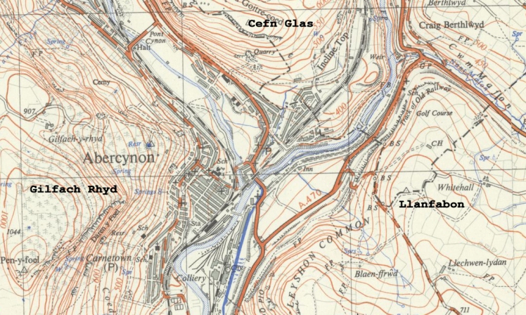
Abercynon sits in the shadow of three mountains: Gilfach Rhyd, Cefn Glas and Llanfabon. The area known as Carnetown stretches up onto Gilfach Rhyd with the clearly defined ridge, Darren y Foel, visible above the old Carnetown Juniour School. From its summit, known as Pen y Foel, the Bristol Channel is visible as, on a clear day, is the Mendip Hills and parts of Somerset, Devon, Brecon and Monmouthsire. At one time 7 parish churches were visible from this point. Above Abertaf and the line of the Aberdare Canal (now New Road) sits Cefn Glas, the old quarry visible until relatively recently. As for our third mountain, Llanfabon, for many years used as the colliery spoil tip, the stretch which runs from Fiddlers Elbow to Cilfynydd is known as Craig Evan Leyshon Common.
It is in Abercynon, at the imaginatively named Watersmeet, that the River Cynon joins the River Taff.
Originally a small community which grew around the basin of the Glamorganshire Canal on the 21st of February 1804 Abercynon was the terminus for the world’s first steam railway journey.
The sinking of the Dowlais Cardiff Colliery in 1889, the last in the Cynon Valley, meant change as Abercynon started to grow. One of the first streets built was Martins Terrace, chiefly for officials at the pit, while Ynysmeurig Road, Margaret Street (originally Commercial Street) Herbert Street (Catherine Street) and Gertrude Street were all built as homes for the miners. For the first half of the twentieth century Abercynon continued to grow and at its peak had numerous churches, chapels and pubs as well as a thriving high street. While much of this has now gone the remnants remain.
